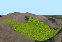
Drones, 3D modelling and GIS have combined to create a tower management system capable of sharing documentation and thousands of images with teams in different parts of the country
Location: Pretoria, Gauteng, South Africa
Sector: Telecommunications
Project team: iSpatial Global Systems South Africa
Completion: 2017
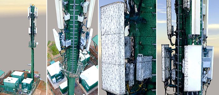
Telecommunication stakeholders in South Africa wanted an iGlobe tower management system (iGTMS) to improve visibility of the many towers they inspect. This R750m (£42m) iGTMS project combined the use of unmanned aerial vehicles (UAVs), 3D reality modelling software and geographic information systems (GIS) to manage all documentation used in all processes.
The organisation hired iSpatial Global Systems South Africa, a world-class engineering company, to create the iGTMS for them. iSpatial Global Systems is focused on geospatially oriented applications in the mining, municipality, utility and private sector, and it works on risk-based inspections across a wide range of sectors throughout South Africa.
Completed in September 2017, the tower management system integrated geographical information, while it also prevented duplication and made relevant information easy to access, and it creates total transparency across projects. iSpatial Global Systems’ project team needed to accelerate inspection time, reduce risk associated with manual site surveys and produce an integrated and geospatially accurate 3D model that would be accessible to a dispersed engineering team.
Generating a Tower Management System
The project team took thousands of photos in the field to create the structural models to implement into the iGTMS with ContextCapture, Bentley Systems’ 3D reality modelling software. The team used a variety of drone types to take the necessary photos for creating rich reality meshes and then used these meshes to explain the environment and structures to the engineers in the office.
ProjectWise helped the team manage the engineering content and other content, including drone mission log files, raw imagery and final reports. By creating basic workflows, the process was easier to understand and avoided missing steps. The team then linked models and content back to OpenCities Map (formerly Bentley Map), which also collected the GIS information. The models were shared to the web and mobile portals so that all users could access the information.
Collaborating effectively
By creating these 3D reality models, the project team improved information sharing among its team, as well as its collaboration among stakeholders. iSpatial Global Systems’ teams are not all located in the same place, making it challenging to share information and results. By sharing the models through the web and mobile portal, all users could access the information they needed from any device.
Additionally, ContextCapture models helped viewers see the detailed landscape and location. Many of the towers are in treacherous locations, either in very remote areas or difficult places to reach, such as on mountains or busy roadways. Knowing this information ahead of time helped the engineers plan appropriately.
The project team easily shared all relevant content to the different teams working on the projects through ProjectWise. Since all the information was updated in real-time, users knew that they were seeing the most up-to-date information, which streamlined the decision-making process. This knowledge improved collaboration because everyone was looking at the same models and easily located them in the system.
Streamlining workflows
The iSpatial Global Systems team saw significant benefits by using Bentley applications to create an iGTMS for its client. The project team created the core management system in a few days and this quick setup allowed the experts to begin working in a managed environment and track all project progress. The team’s processing time was reduced from one week to one day, and the test sections were reduced from a day or two to a few hours.
These decreases allowed the team to make quick changes to the plans and adjust the drone pilots’ missions and flying methodology accordingly. Bentley’s ContextCapture saved the project significant time and money. The high quality of the model was unlike any other of the organisation’s processing technology. Also, the application could model different scenes and add them together later as one production.
This capability not only helped break the project down into smaller sections, but it also allowed the team to conduct smaller sample tests during the research and development stages. These smaller tests produced results in minutes rather than days, speeding up the process.
ProjectWise also helped the team set up standards, naming conventions, workflows and audit trails. These listings saved time in tracking projects and results during research and development. Lastly, the team organised and standardised its geospatial content with OpenCities Map, making it interoperable with other technologies and saving both time and cost.
Future positive impacts
iSpatial Global Systems expects to see a positive impact on its local and global markets by using Bentley applications. Previously, the organisation tried to balance time and cost savings with information accuracy and technical people’s safety. Now, the iSpatial Global Systems team can speed up the collection of accurate information using UAVs, model in ContextCapture, store the geographical information in OpenCities Map, and manage resources in Project-Wise. The telecommunication stakeholders will use this method as a point of reference on other projects in the future.

Chintana Herrin
Reality Modelling Product Marketing Manager
Tel: +44 207 861 0900


