BIM may seem like a daunting journey into the unknown for some but breaking down the process into manageable chronological stages is by far the best way to start
Whether you’re a beginner or experienced practitioner, there are now international standards (ISO 19650) that explain the process of creating consistently structured data and documents for built environment projects.
Here though, in an interview with FARO’s Oliver Buerkler (senior product manager, construction BIM) and Marc Zschieschang (product manager, Construction BIM), we look at the initial stages of a construction project – surveying an existing site and the process of what is known as ‘scan to BIM’.
Sometimes referred to as ‘as-built’ modelling, this should not be confused with the process of verifying what has been newly constructed through the use of laser scanning. In FARO’s Traceable Construction terms, this falls into the ‘onsite capture’ and ‘as-built modelling & design’ stages. We will focus here on the as-built modelling stage.
As the BIM process is about creating consistent, more complete information, the best place to begin is with the greatest possible understanding of ‘what’ your site is. Laser scanning (or photogrammetry, as an alternative) is so much more cost-effective now that it makes very little sense not to do it.
In introducing the solution, Buerkler says: “Our approach here is to help professionals turn reality into an intelligent digital representation, the BIM process (in most instances) requires designers to work in a data-rich 3D environment where traditional 2D deliverables can also be quickly taken from the models.”
The files created by a laser scanner tend to be quite large and while most BIM authoring 3D software has the ability to import and display ‘point clouds’, working with them can be quite unwieldy.
Zschieschang continues: “Every project has a site that needs to be measured – whether it’s a family house with five scans to a complex 5,000 scan masterplan project, the challenge is to subdivide the point cloud to make manageable sized segments.”
Once users have subdivided the point clouds, the modelling can begin. While other modelling solutions offer ‘mesh surface’ production from point clouds, the resulting model is not considered to be ‘BIM’ – that is, it lacks the ‘I’ part. The FARO solution therefore gives users the best possible start, by using intelligent objects.
FARO has created As-Built for Autodesk Revit, a software add-in that enables enhanced functionality over the standard Revit software capabilities. Users can semi-automatically generate building elements by selecting ‘Real 3D’ points in the point cloud – something Revit cannot natively do.
Zschieschang explains: “The software matches the wall thickness, for instance, to wall types in the user’s library and places the wall accordingly. The next step is to place openings in the wall using similar steps – by selecting points of a window or door in the point cloud, the software selects the right sized item from the library and places it in the wall.
“If the library item cannot be found or doesn’t suit, the software assists you in creating new families – again using the point cloud. This can be repeated for precisely placing other items such as openings, walls, doors, windows, columns, beams and pipes for a complete set of architectural, structural and MEP as-built models.”
In projects where it is applicable and reasonable to do so, the FARO software has the ability to correct the angles of walls within a specified tolerance to allow for more ‘tidy’ models. When working on heritage projects, for instance, where a true representation of the conditions is required, this would be an unlikely feature to use, but some projects in existing buildings can benefit from truly orthogonal models.
With respect to MEP items such as pipes, the FARO software enables users to specify an insulation diameter factor. This ensures that the model created represents the true pipe or duct size inside the insulation, rather than modelling the dimensions as per the outside surface as recorded by the laser scanner. This is an essential ‘user assisted’ step for those using their models to run pressure/temperature drop or flow rate calculations.
A similar approach has been taken with Autodesk’s Plant 3D software – an add-in allows models to be created from library components, but to add the true BIM factor – the add-in then has the ability to export to Autodesk’s Revit software and replaces all extracted items with Revit items that can then hold more data.
This software workflow enables users from any discipline to save time and money with automated functionality, while maintaining integrity, traceability and accuracy.
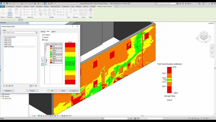
Another feature of the software is the deviation analysis tool – models can be compared against the point cloud to ensure the model is built to meet the accuracy and tolerances required. The software will highlight in real-time, where the model is outside of the requirements to enable corrections to be made. These analyses can be exported as a report to demonstrate accuracy and even has built in templates for USIBD (US Institute of Building Documentation) checks, for instance.
In summary, FARO’s user-assisted modelling solution takes a best practice approach to the ‘scan to BIM’ process and in Zschieschang’s words “brings the reality to the model”. As a key initial stage of the BIM process, the as-built models created using the steps described can then be used as a basis for design work to begin. Fully appreciating the site, building, road or rail line a project team is about to work on is a significant step forward for our industry.
An ongoing added benefit is that the point cloud can remain as a reference throughout the design and construction stages to ensure ongoing accuracy or to ‘complete the picture’ where real-world items have not been required to be modelled.
The FARO solution enables skilled, experienced architects, engineers or surveyors to interrogate and model from scan data while using their professional knowledge and intelligent software to help them create accurate digital representations. The vital part of the FARO solution is the ability to allow built environment professionals to determine the construction or make-up of the existing site – something that automated systems cannot yet do.
Anke Abendroth
Content Marketing Manager EMEA
FARO UK
Tel: +49 (0)7150 9797 – 311
Twitter: @faroeurope
Please note: this is a commercial profile.


