Here, in an interview with Chris Palmer of Faro, we look at the opportunities afforded by ‘mobile mapping’, how it differs from static survey methods, what the resulting data looks like and who can benefit from it
Those familiar with static terrestrial laser scanning will understand that the technology (hardware, software and cloudware) behind it has enabled us to affordably and accurately capture information about our built environment in increasingly more impressive ways.
As the phrase suggests, the primary difference between static and mobile mapping is that the hardware capturing the survey data is doing so while mobile. There are, of course, various types of ‘mobile’ data capture but here we look at land-based capture rather than aerial or waterborne.
Even with the relative simplicity of being land-based, the technology required to ensure that the data captured is useful and accurate is impressive. The challenges obviously, then, are that the vehicle-mounted hardware (road or rail) needs to account for the movement in all dimensions.
Without diving into too much technical detail, the solution Augusto describes in this SITECO example includes two Faro Focus laser scanners, one Ladybug5 ‘spherical’ camera and an Inertial Measurement Unit (IMU) and is badged as the ‘Road-Scanner C’ solution.
In short, each piece of equipment does the following:
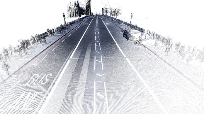
The laser scanners are rigidly mounted to the vehicle at 45 degrees with their coverage overlapping. As part of the mobile mapping system, they don’t actually operate in the more familiar ‘3D mode’ associated with static surveys but as ‘profilers’ recording scan-lines or ‘profiles’ of the environment. When combined, both units create a 3D point cloud and are capable of capturing 2m points per second.
The Ladybug5 camera captures a 360-degree spherical photographic image concurrently alongside the scan data.
The IMU is the brains of the set-up and records accurate location using two GPS receivers, which work concurrently to record ‘position’ and ‘heading’. The GPS data is supplemented with velocity, pitch and roll sensor data, with software then essentially cancelling out the vehicle movement and enabling each scan line to be accurately recorded and geo-referenced.
In terms of accuracy, the combination of this equipment provides an absolute (position in the world) accuracy of 1-2cm and a relative accuracy (relative to the scanner) of 7mm at 20m distance – quite an achievement when the vehicle is moving at 36km/h.
The case study Chris Palmer discusses uses the SITECO ‘Road-Scanner C’ for capturing a 30-mile stretch of the M62 motorway in the UK.
With an on-site data capture time of 1.5 hours, and travelling at 70km/h, Chris recalls that the resulting processed 60gb dataset was a 20cm grid of overlapping profiles. He comments: “Of course we can travel at slower speeds to record in more detail, with the grid density increasing. For example, if we travel at 36km/h the grid density would be 10cm.”
As impressive as the hardware is, for Chris “the highlight is the software, some software allows the instant translation of coordinate systems, automated ‘feature extraction’ that recognises terrain/surfaces and line-work such as road markings, and even ‘classification’ of the identified objects to allow linking to other data sources”.
Some software advancements are specific to Faro too – with the increasing requirement for access to scan data, Faro has created a Cloud Point Exchange (.cpe) format that compresses the data.
In real-world terms, the compression is huge. In one example, Chris says “our 60gb of raw scan data can be compressed down to 1.5gb, which can then be streamed for viewing in a web browser” – making data that was once only viewable with expensive software now accessible to many more people.
So with regard to value of using a mobile mapping process and the resulting dataset, the value is split into two groups – those who capture the data and those who consume the data.
The value for surveyors is clear:
Whether financial, quality or time-based. The capital cost of the equipment, for example, not only provides the ability to offer mobile mapping services but each of the two laser scanners can be used independently for static scanning purposes for those clients not requiring the ‘mobile’ aspect. In time terms, reduced capture time (when compared to traditional measurement techniques or even static scanning) is clear as outlined in the case study above in the scale of data recorded, the added accuracy and the ability to create high-grade, affordable mapping deliverables that fit with a BIM process.
The value for clients, designers, contractors and asset operators:
This is really where the deliverables really begin to make a significant difference over traditional methods or uses. Delivering a dataset that enhances accuracy, provides bigger picture context and gives greater confidence in decision-making is changing the way professionals provide services in our industry.
Whether semi-automatically generating a GIS (Geographic Information System) Asset Management database through object recognition software or delivering a point cloud to someone who will model a 3D representation of it using a BIM authoring tool, the process begins with the best possible dataset. This minimises error, improves accuracy and increases the accessibility of the information using web-viewing technology – giving the right people access to the right information at the right time.
Even where ‘design’ is not required, mobile mapping affords clients the opportunity to undertake cost-effective infrastructure condition inspections – covering swathes of land/assets in periods of time previously unachievable. Benefits indeed.
Summary
In summary, we can see that once captured, processed and used within a managed design and construction environment, the data can be reliably accessed and used by various stakeholders where permitted.
In using what is essentially a highly effective combination of existing solutions when recording, translating and presenting data, we ensure accuracy and veracity of the survey data.
Ultimately, survey technology has moved on considerably and it’s still accelerating to cater for today’s ever-increasing desire for the most up-to-date information. To quote the technology journalist Graeme Wood “change has never happened this fast before and it will never be this slow again”.
Anke Abendroth
Regional Marketing Manager
FARO UK
Tel: +49 (0)7150 9797 – 311
Twitter: @faroeurope
please note: this is a commercial profile


