UAS technology provides near limitless potential to capture big data in a safe, efficient, low-carbon and cost-effective way, say Caroline Raynor and Dean Bain of Costain
Unmanned Aircraft Systems (UAS) are increasingly at the forefront of intelligence gathering across multiple sectors including construction, defence and the environment. The Civil Aviation Authority now has a three-strand programme to support how the industry can use UAS or drones to address their monitoring and data-gathering challenges.
Costain has been using UAS technology for over a decade for data gathering and providing rapidly deployable digital solutions to meet clients’ needs. As early adopters, Costain’s complex delivery teams now rely on this airborne technology, and the team of 20 in-house trained and qualified pilots, to support measuring, monitoring and designing for the environment in which they operate.
Using UAS across complex delivery projects allows Costain to quickly amass data across hugely varied environments and to do it safely. Recent projects including London Underground, National Highways and HS2 Ltd have allowed the team to develop their offering and align it with other digital capabilities including Artificial Intelligence (AI), Building Information Modelling (BIM) and Geographic Information Systems (GIS).

Producing effective designs from project inception to completion
Costain’s head of AI, Tim Hall, sees the value of UAS inputs into the growing AI space: “We can adapt the same AI technology that produces imitation Rembrandts to learn from UAS data in the construction sector. These algorithms can quickly simulate the extent and impacts of specific construction activities across large-scale infrastructure projects and help us produce the most effective designs from project inception to completion.”
UAS technology forms a valuable part of safe systems of work. Drones are regularly used to carry out pre-demolition surveys, where additional information about a structure’s fabric and build can minimise impacts on the workforce and surrounding communities. Identifying structural anomalies and monitoring any changes gives additional certainty during the demolition process. This resulting footage can then be used elsewhere in the business. Good examples include as part of colleagues’ inductions, interactive method statements or toolbox talks.
Equally, when safety incidents arise, the team can be deployed to gather data about the event, the environment and the conditions. This enhances the quality of the investigation and subsequent decision-making and future mitigations.
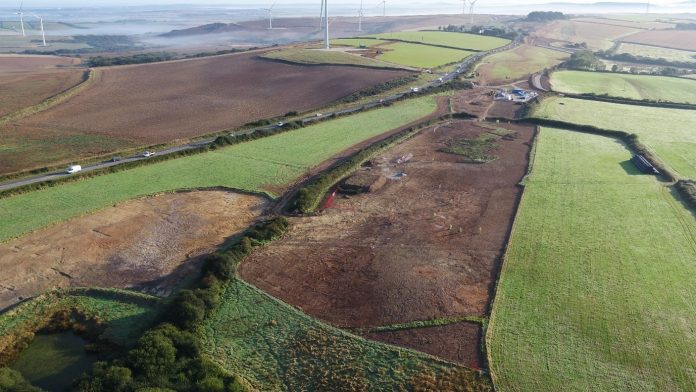
Often construction programmes have close ties with specialist disciplines such as ecology and archaeology. Costain regularly incorporates UAS data and surveys to interpret and record heritage assets in a way which can be beneficial to stakeholders including Local Planning Authorities and Historic England.
On a recent condition survey of Grade, I listed Kensal Green Cemetery in North London, with just 15 minutes of flight time we were able to generate a highly accurate 3D model of the 72-acre historic site and thousands of designated and non-designated heritage assets.
UAS pilot Saul Willoughby noted that “the resulting information is accurate enough for engineering requirements and has a valuable secondary output for community engagement, generating a new way for the public to visualise their heritage”.
UAS technology can be used to protect the environment surrounding construction sites
UAS technology can also be used for environmental protection around construction sites. For example, during nesting bird season monitor trees and buildings for nesting activity, ensuring compliance with Wildlife and Countryside Act 1981. Previously this work was carried out using powered access equipment. Using a drone with a zoom camera removes the risks associated with working at height and eliminates plant and vehicular emissions.
Covid-19 posed major challenges when it came to gathering information and monitoring operations remotely. Aerial still images, photogrammetric data and video footage were used to make operations more visible and more resilient by providing clients and stakeholders with real-time data for site inspections, progress updates and virtual site visits.
Engineering applications aside, footage filmed by Costain has been used by regional and national television, including recent news coverage of the A30 scheme and Britain’s Biggest Dig – the three-part series documenting the archaeological works across HS2 for the BBC.
What has become clear is that the use of drones provides the near-limitless potential to capture big data in a truly safe, efficient, low-carbon and cost-effective manner. The innovative approach Costain is taking to using UAS technology has enabled the development of new workflows and provides adaptable solutions for an ever-increasing range of situations and stakeholders.
Contributors: Richard Bath and Saul Willoughby – Costain Group
Caroline Raynor
Senior project manager
Dean Bain
Senior project manager for surveys
Costain
Tel: +44 (0)207 796 5840


