David Fowkes of GeoSLAM explains how SLAM technology is helping construction teams around the world build a detailed picture of sprawling and complex historic structures ahead of restoration
The restoration of one of Budapest’s distinctive landmarks is certainly good news for a city that last year attracted around 4.6m overnight visitors, almost double the number who stayed in 2009.
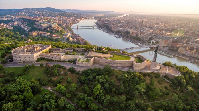
Standing on top of Gellért Hill, the Citadella is a 19th century fortress dating back to the Habsburg era, with a commanding view out over the city and the Danube River. Over the years, it had fallen into disrepair – now it is getting a new lease of life as part of a major three-year redevelopment programme to create a visitor attraction which includes a park and museum.
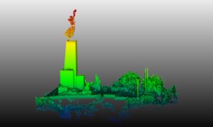
Although a press conference held in June signalled the official start of the project, the preparations began long before that. With work due to begin in the autumn, surveyors from Budapest-based firm Burken has already captured and processed the site data needed to create a detailed 3D representation of the structure, which is close to the iconic Liberty Statue.
Overcoming challenges
Mapping a historic site like this can be difficult for surveying teams. The building could be unlike anything they have encountered before, and accurate and up-to-date floor plans and elevation drawings may be unavailable. Narrow staircases and passageways, as well as poor lighting, structural weaknesses and uneven floors, make some areas inaccessible and possibly dangerous too.
3D remote laser scanning using GPS is a common solution in unstable and difficult-to-reach places such as quarries and opencast mines. But lack of coverage inside buildings and underground mean that GPS-enabled devices are unsuitable for many construction projects, including restoration work.
The Citadella was designed to be impenetrable and its sprawling structure, covering an area of around 13,000 sq m, meant that surveying the site could be a challenge – but it was one the team at Burken was more than capable of rising to.
No strangers to complex sites, its surveyors have previously worked on Budapest’s Castle Garden Bazaar (a short walk from the Citadella) and deep underground in mines and nuclear waste storage facilities. They knew they would need specialist equipment to map the Citadella’s vast courtyard and labyrinthine network of tunnels, turrets, alcoves and bunkers, so they enlisted our support early on.
Using SLAM technology
One reason why Burken has become an expert in mapping historic sites like these is because it was an early adopter of SLAM (Simultaneous Localisation and Mapping) technology. First developed in the robotics industry, the SLAM algorithm powering our devices means they are capable of scanning indoor, enclosed and otherwise difficult-to-reach places, where there is no GPS coverage.
Unquestionably, mobile scanners would allow the team to map the structure far quicker compared to using terrestrial devices, which would also help to reduce project delivery times.
In fact, the team scanned historic site, the Citadella in just 30 minutes – a fraction of the time it would once have taken to capture the same data using traditional surveying methods. Not only that but older equipment can also be unwieldy, making it unsuitable for tight spaces anyway.
Depending on the device used, a ‘walk and scan’ method of data collection allows operators to capture 300,000 points per second and record distant features at a range of 100 metres.
Structures can be scanned in minutes or hours, not days and weeks, which saves time and money, while reducing the amount of time someone spends in a potentially hazardous environment. In fact, the latest handheld scanners allow you to digitally capture 3D data 10 times faster than traditional scanners, with post-processing complete in three-quarters of the time. So reliable is the technology that only one site visit is needed, though a second or third scan can easily be undertaken if the project demands it.
Handheld scanners enable surveying teams to capture every nook and cranny of a building, but where confined or hazardous spaces require hands-free movement, they should be able to mount them to a pole or backpack too.
Data management
Once collected, the data is processed to create an accurate 3D map using BIM (with costs and timescales included) that can be shared with stakeholders at every stage.
While it is always rewarding to see a new project get off the ground, the restoration of a unique building like the Citadella is particularly so. Once complete, it will take its place among Budapest’s well-known attractions, including Buda Castle, and add to its already rich heritage.
Digital technology, including mobile scanning and BIM, is changing the face of construction, from new builds to historic sites, enabling partners to work collaboratively to reduce delivery times and costs, increase safety standards and engage stakeholders.
Where margins are tight and the public is watching closely, as is usually the case with projects of this nature, technology like SLAM helps to ensure they are feasible before work gets underway and then stay on track to deliver value-for-money.
To see a 3D model of Budapest Citadel, captured using the Zeb Revo, click here.
David Fowkes
Global strategic sales director
GeoSLAM
Tel: +44 (0) 1949 831814


