OpenSpace, a leading AI construction tech company, enables field teams to navigate BIM models on-site
When you’re using a BIM model on a project, you want to get it into the hands of those doing the building. While BIM has been widely adopted in the design and engineering sectors, the need for special skills and complicated BIM coordination software remain major blockers for field adoption.
The OpenSpace BIM+ package of user friendly tools bridges the BIM gap by tying reality capture data to your model directly in their system. Project team members on-site can easily view, navigate and understand the model alongside site images.
Leveraging reality capture data for better BIM coordination
Creating a site capture of your project is the foundation for better BIM coordination between the field and the office.
To create a capture, simply attach a 360 camera to your hard hat, tap record on the OpenSpace app, then walk the site like you normally do – you can also use a selfie stick or even a drone to capture. The OpenSpace Vision Engine then maps the photos to your floorplans and BIM model automatically. The result is a complete, interactive, as-built record of the construction site or building.
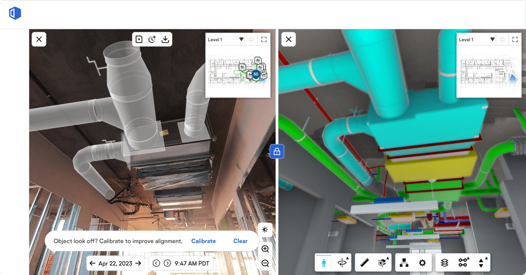
If you have a BIM model uploaded to the system, your model will be fully aligned with your captures. You can even turn layers on and off and snap measurements in your model.
Use the Sheet Overlay feature to view your sheet drawing overlayed on the aligned floor of your BIM model, helping you better connect the 2D drawings you look at daily to the 3D information in your model.
Accelerate office and field coordination
With their latest product, OpenSpace BIM+, the company is taking simple and easy BIM coordination to the next level.
Share Saved Views
Saved Views makes BIM navigation fast and easy for anyone. When you want to view something specific in your model, you might need to turn off layers, elements or systems.
Once you’ve turned off those items in BIM Compare, simply save the view so you (or other team members) can come back to it later.
Bring your BIM into reality
With the BIM Element Overlay feature in OpenSpace BIM+, you can quickly discover if an element is missing or if items are installed in the right place.
Choose items from the model, such as an HVAC grille, and overlay them onto the image of your on-site condition. The ability to see elements in your 360° photos and answer questions improves your quality control.
Collaborate better
As you compare and analyse your on-site condition against the model, easily call out any discrepancies by creating a BIM Compare Field Note – these notes include the image and the model in a single view. Mark up, tag, and immediately share your field notes with all relevant team members.
Connect with the tools you already use
Field Notes in OpenSpace integrate easily with BIM coordination tools, resulting in streamlined communication and workflows.
Export multiple Field Notes to a BCF file and then import them as issues into any solution that accepts BCF format. Now you can access your Field Notes directly from your BIM program, including all associated data, as well as 3D coordinates (meaning your imported data lives in the correct coordinate space).
Align with your point cloud
If you have laser scan data on a project, you can use that data to compare your on-site build with your model with point clouds in BIM Compare – perform visual clash prevention and deviation analysis within OpenSpace.
Now your field teams can access and view the information and solve coordination problems instantly, without relying on a BIM specialist.
Use on-site and on the go
Ensure models are in the hands of the field with BIM offline mode. Since connectivity can be an issue on-site, and it’s time consuming to search for a spot with a connection, use offline mode in the OpenSpace mobile app to access a downloaded model for reliable viewing out on the project.
Trusted by industry leaders
OpenSpace users have captured more than 2.5bn sq m on over 33,000 projects in 93 countries.
In the UK, companies like Wates, Vinci and King & Moffatt streamline cross-team coordination with 360 reality capture from OpenSpace.
TClarke is one of the first regional customers rolling out OpenSpace BIM+ across several major projects in London.
Mark Lawrence, group chief executive officer at TClarke, said: “By using OpenSpace’s latest product, OpenSpace BIM+, TClarke aims to streamline coordination between design and site teams, allowing us to align the as-built to the BIM model and identify issues early on.”
If you would like to see how OpenSpace BIM+ can help your field and office teams work together more efficiently, you can scan the QR code to request a short, personalised demo.

Test drive OpenSpace with our free demo:
*Please note that this is a commercial profile.


