Land surveying is an essential part of maintaining and modernising British rail. Terrestrial laser scanning and mobile LiDAR, along with drones, can be the precision measurement tools that help get the system back on track
The United Kingdom has always punched above its weight. From famous literature to the discoveries of hydrogen, penicillin and gravity, our list of firsts in the world is impressive. This is especially the case when it comes to industry and the nation’s rail network.
Spanning over 32,000km and launched in 1825, the system is about the same extent as the rail network in the US states of Texas, Illinois and Ohio combined.
However, what it lacks in size, it overperforms; or at least has overperformed historically.
As one might expect when you’re 199 years old, a few things inevitably start to fail. Throw in variables like climate change – according to the Met Office, winter 2024 was the second warmest for England and Wales combined and the eighth wettest on record, with some parts of the UK running 248% above normal for precipitation at certain points – and a host of additional problems can crop up.
Landslides can result from excessive rainfall as happened in March on the Shrewsbury to Wolverhampton rail line. Downed electric and telephone lines and trees from high winds can block tracks. And damage to embankments can radically alter the near-track landscape, leading to significant delays, cost overruns, economic disruption, derailments and possible loss of life.
For these reasons (and more) land surveying is an essential part of maintaining and modernising British rail.
Land surveying to the rail rescue
Land surveying is the process of measuring and mapping land areas to determine boundaries, topography, and features. This is crucial for property ownership, construction and land development.
Surveyors use various tools and techniques, including GPS, GNSS, theodolites and 3D laser scanners, to collect precise data.
For British rail, the two types of surveys most relevant are topographic surveys and construction surveys. Topographic surveys include detailed terrain mapping and physical features mapping, whereas construction surveys help guide construction projects.
New projects that seek to place track on already developed land or relocate existing track might also require boundary surveys (for property lines) and subdivision surveys to divide land into parcels.
By being able to measure differences in landscape topography from scan to scan, mobile LiDAR and terrestrial laser scanners can be cost and time saving tools. Not only to map and measure the aftereffects of a landslip but to serve as a preventive solution, detecting even miniscule ground shifts before a landslip occurs.
Equipped with this imaging technology, vulnerable embankments can be augmented with temporary retaining walls, in case of inclement conditions.
Weather aside, projects like the HS2 (slated to open in the 2030s) that will cut rail travel times in half between London and Birmingham, with extensive route mapping, tunnelling, stations and viaducts, are well positioned to take advantage of terrestrial, drone and mobile scanning technology.
Fortunately, the nation is beginning to take note.
Earlier this year, a drone deliveries, surveys and monitoring company and the UK’s leading environmental maintenance and biodiversity company partnered with Network Rail to streamline infrastructure surveys for the agency.
According to the surveying company’s February 2024 press release: “By capturing mission-critical environmental data, vegetation encroachment, tree type and health, the service enables the UK railway infrastructure owner to make data-led decisions on their vegetation management, reduce impact on biodiversity, respond rapidly to risks and limit delays for rail users.”
Tracking terrestrial and mobile laser scanners
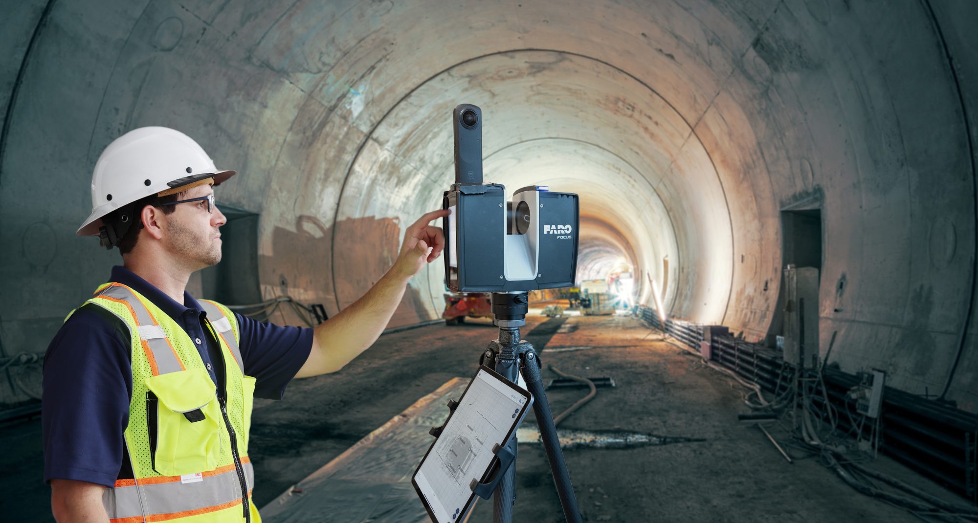
This is just a sampling of what 3D laser scanning technology can do. Terrestrial laser scanners like the FARO Focus Premium Laser Scanner, can capture accurate and complete measurements of complex natural environments with ease, and speed.
That speed is due in part to Hybrid Reality Capture™, powered by Flash Technology™, a scan mode for the FARO Focus Premium Laser Scanner that combines the accuracy of a 3D scan with the speed of a panoramic camera.
By interpolating data points, Flash Technology enables fast scans in under 30 seconds with colorised 360° images that save up to 50% scanning time.
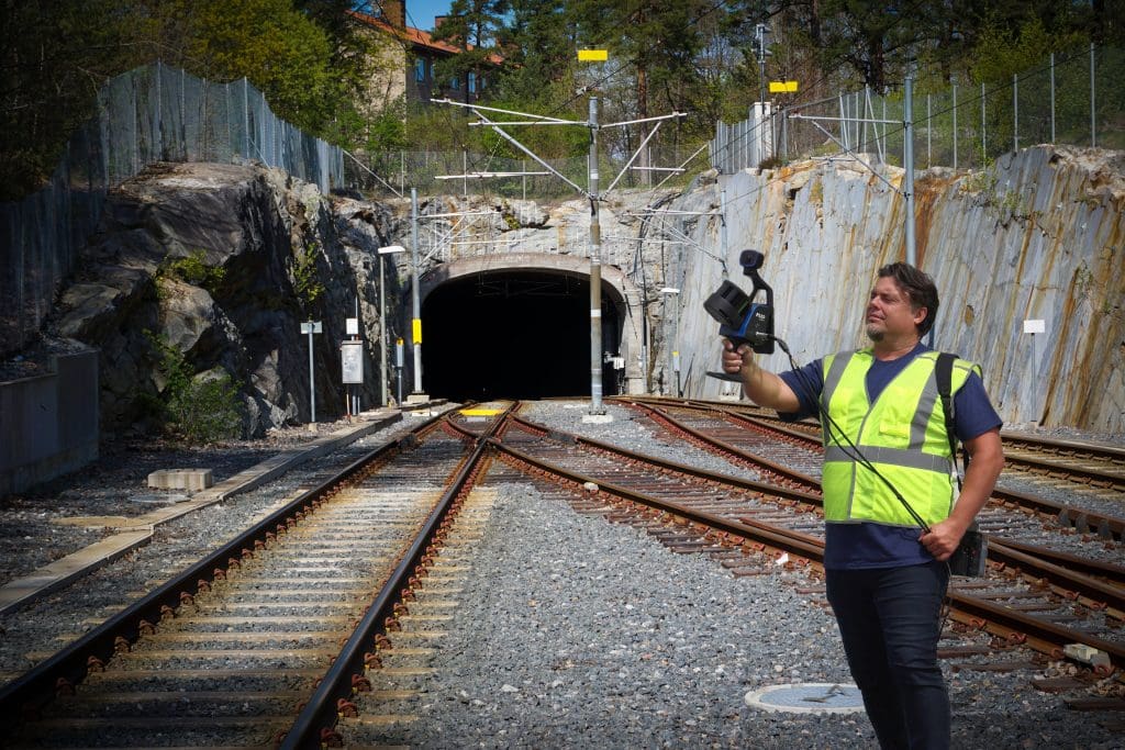
When maximum speed and agility are key, the FARO® Orbis™ Mobile Laser Scanner may be the way to go.
Powered by GeoSLAM’s proprietary SLAM algorithm, Orbis returns highly accurate 3D point clouds and also integrates with FARO’s Flash Technology, allowing for stationary scans in just 15 seconds. Capable of capturing underground rail, tunnels and bridges faster (Network Rail oversees 30,000 bridges, tunnels and viaducts) operators using this tool can gather much more data, faster.
In railway applications, speed and accuracy of data are essential assets. While drones like those Network Rail are already employing no doubt do their jobs well, the combination of Focus and Orbis, working as complementary solutions, along with their software suites and cloud-based data sharing/project management with FARO Sphere® XG, makes for a more complete laser scanning ecosystem of data.
This allows operators the freedom to choose between the two devices as land and subterranean surveying needs dictate. For some applications, Focus will be the preferred choice due to its greater accuracy. In other instances, Orbis will win out due to its speed of capture.
All aboard for future success
To be sure, Network Rail inherited many challenges from its predecessors. And many challenges remain.
Public opinion on the country’s rail network is mixed. In a Guardian opinion piece, writer John Harris was critical in his assessment, describing the recent history of our trains as “a plunge into underinvestment.”
And, in an Ipsos survey on the top reasons to be proud to be British, our Victorian-era railroad didn’t make the cut (The National Health Service topped the list with 55% of respondents noting its achievement, followed by our history and the Royal Family.)
But if you’re being charitable, “our history,” includes our famous-turned infamous rail. After all, it was the first in the world. And that counts for something. It’s a significant legacy to live up to. Today, British trains carry 1.8bn passengers per year and over 100m tonnes of freight.
Only by fully modernising the network’s 32,000 km, and only by ensuring safety and reducing travel times, will the British railway system live up to its full potential.
Terrestrial 3D laser scanning and mobile LiDAR, along with drones, can be the precision measurement land surveying tools that help get the system back on track.
Unlock the potential of 3D laser scanning to enhance your land surveying process today. Click here to learn more.
*Please note that this is a commercial profile.


