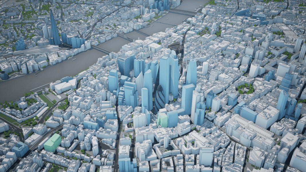
AccuCities is a London-based specialist 3D city modelling agency. Using manual photogrammetry from aerial imagery, AccuCities captures 3D models of existing as-built environments, from small site models to 3D models of entire cities
Over the past seven years, AccuCities 3D models have been used on over 4,000 projects by almost 300 customers – mostly architects and planning consultants.
These models have also been used in unique environmental studies, visualisations, video games or even to train advanced AI systems.
Remote mapping using Stereo Photogrammetry
AccuCities uses manual photogrammetry to create 3D maps from aerial imagery. Photogrammetry is the science of making measurements from photographs, especially for recovering the exact positions of surface points.
As a survey plane flies over a city area, it takes a series of photographs which overlap by 60%.
Once the imagery is postprocessed, we project one image into one eye, the second image into another eye and this way the technician is able to see the Z value (depth).
For Level 3 models all roof features are manually captured, resulting in 3D buildings models with consistent accuracy and correct geometry.
To make Level 2 models lighter, we only capture the roofs and significant features for this medium accuracy models. Level 3 models are accurate to 15cm and Level 2 models to 50cm in all axes.
The terrain 3D model is the same for both Level 2 and Level 3 models. Height points are captured along curbs of roads, along green spaces and footpaths, as well as any significant change in terrain profile.
This results in an accurate and detailed 3D terrain map, which is further post-processed to make the CAD format solid and separated into layers. Trees are captured at the height and width of the canopy and post-processed into 3D trees models or a database.
Where more detail is needed, AccuCities further enhances these models to include windows and facade openings, architectural detailing, materials or even textures.
3D City models library
AccuCities manages a library of 3D city models for its customers.
These include Cardiff, Birmingham, Bristol, Milton Keynes and, of course, London. In complex urban environments, it is not enough to capture detailed and accurate 3D models; it is also necessary to keep the models up to date.
That’s why about every 1,000 days, the entire 3D model of London is remapped from the latest aerial imagery. The 3D London model has been captured from 2016, 2019 and 2022 imagery, with the next model overhaul scheduled for 2025 To enable the best understanding of the as-built environment, AccuCities also creates the Future Skyline Layer. This collection of 3D models of skyscrapers and other landmark developments that already have planning permission granted.
Especially in areas of rapid development such as the City of London, Canary Wharf or Nine Elms area of London, Future Skyline Layer enables users to plan and design buildings with other significant developments taken into account.
Plan.City urban planning app
Plan.City is an Unreal Engine-powered urban planning app. The app is used daily by several UK architects, planners, consultants and even construction companies to quickly create design iterations compliant with local and national restrictions and regulations.
3D models user case studies
AccuCities has a wide range of customers, who use the 3D city models in a variety of ways. Planning consultancy clients such as Anstey Horne, Delva Patman Redler or EB7 use the 3D models to support their advice in areas such as massing impact daylight studies, solar glare studies, transient overshadowing studies and many, many more.
Architects such as KPF or MAKE Architects use AccuCities 3D models to position their design into the existing environment and subsequently use it to generate pedestrian wind comfort or solar energy studies but also help them to create visualisations and even encourage community engagement.
“Where more detail is needed, AccuCities further enhances these models to include windows and facade openings, architectural detailing, materials or even textures.“
And construction companies such as BAM use 3D models to simulate site access, scaffolding & cranes locations.
Outside of the AEC and planning industries, AccuCities 3D models have been used in several videogames. The London model was used by Microsoft to train the next generation of unmanned aerial vehicles. And it was also used by researchers from University of California (Berkeley), Stanford University and Bytedance Research, who used the model to train AI to develop a platform for research of learning abstracted high-level holistic 3D structures. When researchers need to understand a city, AccuCities is where they start.
How to order AccuCities 3D models
AccuCities services now cover 99.8% of the UK. Where models are not ready-made, AccuCitities is capable of capturing custom 3D site models from 0.1 km2 (330 x 330 metres), all the way to the 3D model of an entire town or a city.
The average delivery time for the custom model is six working days. The model can be delivered in CAD solid, SketchUp, FBX or Revit format. Use the AccuCities Quoting Tool to get an instant estimate of the cost and delivery time.
If the 3D model is already captured in the AccuCities library, customers can purchase the model in 500 x 500 metres tiles, with same-day delivery.
Users who work on multiple projects in the city or require access to the entire city model can subscribe to the entire managed dataset and even receive updates throughout their subscription period.
Sandor Petroczi
Director
AccuCities
Tel: 00442035744719
sandor@accucities.com
www.accucities.com
X
LinkedIn
*Please note that this is a commercial profile.


