
AI is here, and it is learning. The question is, will it prove to be a labour-saving, efficiency-boosting imitator of human intelligence for the UK’s geospatial mapping or an alarming interference?
“No 9000 computer has ever made a mistake or distorted information. We are all, by any practical definition of the words, foolproof and incapable of error.” – HAL, Artificial Intelligence, 2001: A Space Odyssey
For readers familiar with those haunting words by Somerset-born author Arthur C Clarke, they are perhaps more chilling today than in 1968 when a malfunctioning artificial brain goes berserk in deep space.
More chilling because what was once science fiction is today science fact. Artificial intelligence is here. It is learning. It is growing. Fast. So fast that deputy prime minister Oliver Dowden sounded the alarm last year at the annual UN General Assembly meeting over a lack of AI regulation.
For the UKs geospatial mapping industry, estimated to be worth £6.8bn by 2027, the question is whether or not the technology will prove an artful imitator of human intelligence or, as in the mould of murderous HAL, become an alarming interference?
Pod bay doors are open
For now, industry and government consensus are one of cautious optimism.
James Kavanagh, head of land & resources of the Royal Institution of Chartered Surveyors (RICS), doesn’t envision an AI-enabled robot apocalypse just yet. Rather, he sees AI as filling an essential manual labour niche, where “above all [AI-powered robots] can take the hard work out of geospatial data capture and post-processing”.
Likewise, the UK government is taking AI and geospatial seriously too. Last year, the country’s Geospatial Commission released its UK Geospatial Strategy 2030, a 52-page document detailing the planning required to ensure the country remains a “science superpower”. One way to achieve that aim is through research money – lots of it; to the tune of £20bn a year by 2024-2025.
Another way, in contrast to Dowden’s position, is to slow-roll regulation, fearing that to do otherwise could backfire.
“You are not actually making anybody as safe as it sounds,” said Jonathan Berry, the country’s first minister for AI and intellectual property in The Register late last year. “You are stifling innovation, and innovation is a very, very important part of the AI equation.”
There’s also no denying the breakneck pace with which geospatial and AI are already advancing outside the halls of government.
Esri UK, the local branch of the world’s largest privately held GIS software company with an estimated 45% market share, predicts machine learning will be the next step. Already one in five FTSE 100 companies are working with Esri to adapt and integrate AI/machine learning technologies.
“The Stupidity of AI”
Of course, one way to address the artificial intelligence or alarming interference question, is to delay answering it. And borrow from James Bridle’s provocative Guardian title, that as impressive as today’s AI seems, it’s still pretty stupid.
Rather than fretting about eventual tech, the UK’s geospatial industry would be better served focusing on the technologies of today that already have an outsized impact on mapping and measuring the world.
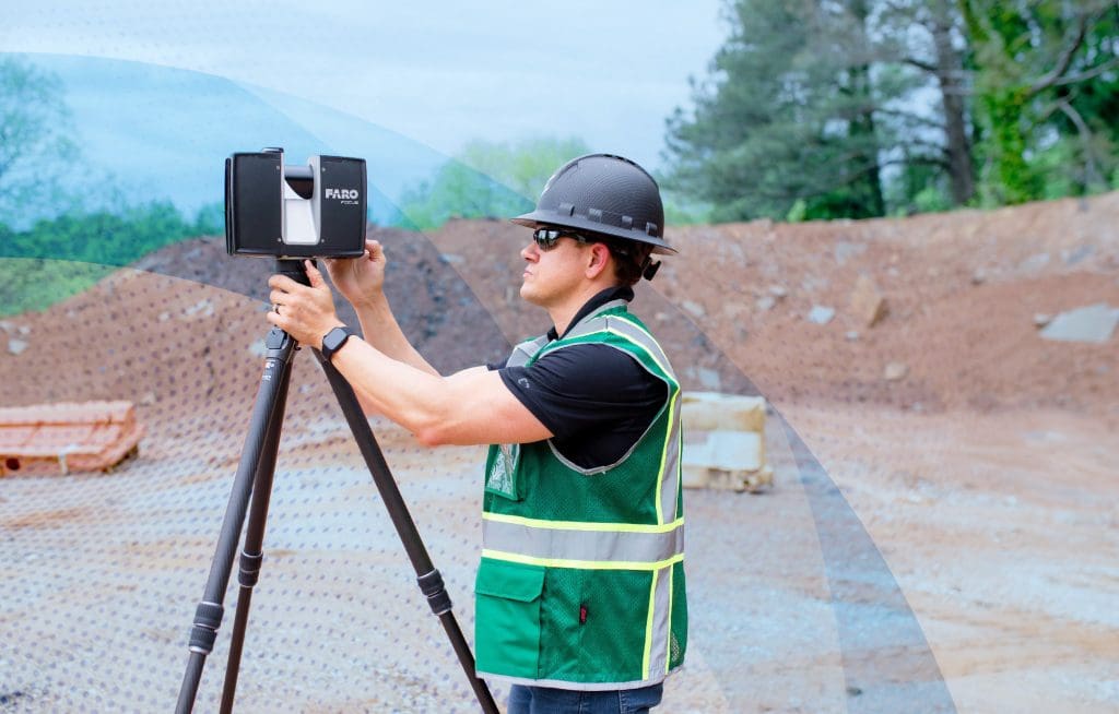
From FARO’s perspective, the company’s two most geospatial-enabled tools are the new FARO® Orbis™ Mobile Laser Scanner and the Focus Premium Laser Scanner equipped with Hybrid Reality Capture™, powered by Flash Technology™, a system that combines the accuracy of a 3D scan with the speed of a panoramic camera – allowing fast scans in under 30 seconds with colourised 360° images that save up to 50% scanning time.
At its core, Orbis is already part location tool thanks to its proprietary SLAM (Simultaneous Localisation and Mapping) algorithm, which enables Orbis to identify its relative position to the point cloud map it’s in the process of creating. While the device is not establishing its latitude and longitude, future iterations of the technology may include these upgrades or be made compatible with existing or next-generation GIS systems.
Even without geospatial capabilities, Orbis is very much a powerful mapping tool for a variety of as-built assets, overlapping to a large degree with the Focus. That includes everything from as-built quality control and infrastructure assessment for roads, bridges and tunnels, to mining and topographical/ terrain applications.
The key distinguishing factor isn’t so much project based, but rather a function of time relative to accuracy. Boasting a 120m range and 640,000 points per second scanned, a three-hour battery life, 512GB of internal memory and its mounting ability on autonomous robots like Boston Dynamics’ Spot®, Orbis is built to go where others cannot.
The Focus Premium is also eager to demonstrate its geospatial worth. With its increased scan time, Focus is best suited for geolocated projects that require even greater accuracy. But this determination is as much subjective as it is objective, depending more on client needs than any standardised industry precept. Unlike Orbis, Focus does include embedded GPS, making it an effective tool in merging BIM with GIS.
Lessons from 2001 for 2024
While it’s true that HAL became the archetype of what to fear when it comes to artificial intelligence gone awry, it’s important to recall how both the cinematic and novelisation of the space drama ended.
The humans won. By pulling out the plug.
AI is only as smart as we allow it to become. And the UK’s geospatial mapping industry stands to gain considerably as new machine learning technologies are developed.
Amanda Hidalgo
Office of Corporate Communications
FARO Technologies
Tel: +1 407 212 7885
www.faro.com
media@faro.com
X
Linkedin
Instagram
*Please note: This is a commercial profile.


